


Contents
- An overview of NAVTEX and its purpose in maritime communication.
- A brief history of the development of NAVTEX technology and its global adoption.
- Transmission Frequencies & message selection
- Selection of stations
- Types of messages transmitted via NAVTEX, including navigational and meteorological warnings, and search and rescue notices
- Message Format and Identification
- NAVTEX stations, coverage areas, and how they are organized internationally
- Limitations associated with the use of NAVTEX
- FAQs
Key takeout
Navtex is an old technology now however its simplicity ensures it remains a useful tool for sailors. It may not have long to go, but it is definitely still worth having.
An overview of NAVTEX and its purpose in maritime communication.
NAVTEX, an acronym for Navigational Telex, is the primary method for broadcasting Marine Safety Information (MSI) and an integral component of the Global Maritime Distress and Safety System (GMDSS). Operating in the medium frequency band of 518 kHz, it delivers messages directly to ships, ensuring that mariners are continually informed of weather forecasts, navigational warnings (including those from the World Meteorological Organization), search and rescue notices, and other safety-related information crucial for safe and efficient maritime operations.
The primary purpose of NAVTEX is to streamline the delivery of safety and navigational information, reducing the need for mariners to monitor distress frequencies manually. Instead, NAVTEX receivers onboard automatically print out messages relevant to their current location, allowing the crew to focus on navigation and vessel operations. The system is designed to be selective, enabling ships to filter out messages that are not pertinent to their voyage, thereby avoiding information overload and ensuring that mariners receive only the most relevant and critical information.
A brief history of the development of NAVTEX technology and its global adoption.
The concept of NAVTEX was developed in the late 1970s. The system was designed to use the telex-over-radio system and was officially adopted as part of the GMDSS by the International Maritime Organization (IMO) in 1988. The system was recognized for its ability to significantly improve maritime safety. By the early 1990s, NAVTEX had become a key component of the GMDSS, with widespread adoption by maritime nations. Since then, the global NAVTEX network has expanded, with stations now covering most of the world’s coastal areas where significant shipping activity occurs. The system has been continually updated and refined in that time to improve coverage, reliability, and the quality of information transmitted.
Transmission Frequencies & message selection
NAVTEX messages are transmitted on specific medium frequency (MF) bands, with the following standardized frequencies being used globally:
- 518 kHz: This is the international frequency used for transmitting NAVTEX messages in English. It’s the primary frequency for NAVTEX transmissions worldwide, ensuring that all international vessels can receive critical navigational and safety messages.
- 490 kHz: This frequency is typically used for national NAVTEX messages, transmitted in the local language of the country operating the NAVTEX station. It allows for disseminating localized navigational information, which is particularly useful for domestic shipping. The UK makes full use of this second frequency, including useful information for smaller craft, such as the inshore waters forecast and actual weather observations from weather stations around the coast.
- 4209.5 kHz: Some regions use this frequency for NAVTEX transmissions, mainly for additional coverage or specific navigational purposes.

Automatic Reception: NAVTEX receivers are designed to operate continuously, automatically picking up any NAVTEX messages transmitted on the selected frequencies. This ensures ships are always up-to-date with the latest navigational warnings and safety information.
Selective Message Reception: One of the critical features of NAVTEX receivers is their ability to selectively accept messages based on their type and geographic area. Each NAVTEX message includes a specific identifier indicating its content type (e.g., navigational warning, meteorological forecast) and the area to which it applies. The receiver can be programmed to only print messages relevant to the ship’s current location and planned route, reducing information overload.
Message Storage and Retrieval: NAVTEX receivers are equipped with memory storage, allowing messages to be stored and retrieved as needed. This enables the crew to review past messages, ensuring no critical information is missed.
Error Correction: To ensure the reliability of message transmission, NAVTEX utilizes something called Narrow Band Direct Printing with Forward Error Correction’, (a technique that involves everything being transmitted twice). This helps correct errors that may occur during transmission due to atmospheric conditions or other interference, ensuring the accuracy and integrity of received messages.
The operation of NAVTEX involves a network of coastal stations, each assigned a specific letter identifier and responsible for broadcasting messages to ships within their coverage area. These stations operate on a scheduled basis, transmitting messages at predetermined times to avoid overlap and ensure consistent coverage.
Selection of stations
In automatic mode, the NAVTEX receiver continuously gathers Marine Safety Information relevant to the yacht’s current location, operating autonomously without requiring manual input. When connected to navigation equipment such as GPS, the NAVTEX device intelligently identifies the NAVAREA the yacht is sailing in and selects the suitable NAVTEX stations accordingly. Alternatively, in manual mode, the user has the flexibility to choose specific stations to receive messages from. For guidance on available NAVTEX stations, use the Admiralty List of Radio Signals Volume 3 Part 1 and the List of Coast Stations and Special Service Stations (List IV).
Types of messages transmitted via NAVTEX, including navigational and meteorological warnings, and search and rescue notices
Immediate Navigational Warnings: These messages include information about newly discovered navigational hazards or changes to navigational aids (like buoys and lights) that could affect the safety of navigation. Examples include submerged wrecks, drifting containers, or unserviceable lighthouses.
Preliminary Navigational Warnings: Issued to inform mariners of potential hazards that may not yet be fully verified or precisely located but are of immediate concern for navigation.
Routine Navigational Warnings: These warnings provide information on more permanent or long-term navigational conditions, such as established exclusion zones, marine construction activities, or long-term changes to charted features.
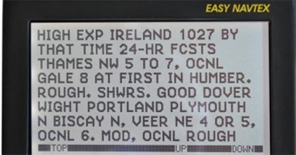
Weather Forecasts: Navtex weather broadcasts provide detailed information on weather conditions expected in the NAVTEX service area, including wind speed and direction, sea state, visibility, and significant weather phenomena like gale warnings, storms or fog.
Weather Warnings: Urgent messages about severe weather conditions that could affect maritime safety, such as gales, hurricanes, or tsunamis, are transmitted to alert ships in the area.
Ice Reports: In areas prone to ice, NAVTEX provides information on icebergs, ice accretion on vessels, and the extent of ice fields, which is critical for navigation in polar and sub-polar regions.
SAR Information: These messages include information about search and rescue operations in the area, including details about vessels or persons in distress, areas to be avoided due to SAR activities, and requests for assistance from nearby ships.
Maritime Safety Information (MSI): A broad category covering any other safety-related messages not included in the above categories, such as security alerts (e.g., piracy warnings), environmental protection notices (like oil spill locations), and information on military exercises or ordnance disposal that could affect shipping.
Administrative Messages: These include information related to maritime safety administration, such as changes to NAVTEX service operations, updates on maritime safety publications, or amendments to regulations that affect shipping.
Message Format and Identification
Each NAVTEX message begins with a header that identifies the message type, its geographic area of relevance, and a unique serial number. This format allows NAVTEX receivers to filter and selectively print messages based on the ship’s location and the preferences set by the crew, ensuring that only relevant information is received and reducing the risk of information overload.
NAVTEX broadcasts use following subject indicator characters:
- A= Navigational Warning
- B= Meteorological Warning
- C= Ice report
- D= Search and Rescue Information/ piracy and armed robbery
- E= Meteorological forecast
- F= Pilot service messages
- G= AIS messages(formerly Decca messages)
- H= Loran C messages
- I= Omega messages
- J= Satnav messages (GPS or GLONASS)
- K= Other electronic navigational aid system messages
- L= navigational warnings (additional)
- M to U= Reserve
- V= Notice to fisherman
- W to Y= Reserve
- Z= No messages on hand
- The navtex receiver can be set to reject messages of certain designations. Messages A,B,D and L cannot be rejected due to their importance.
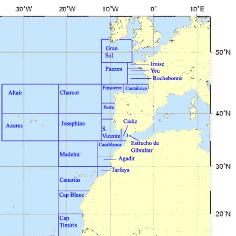
NAVTEX stations, coverage areas, and how they are organized internationally
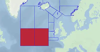
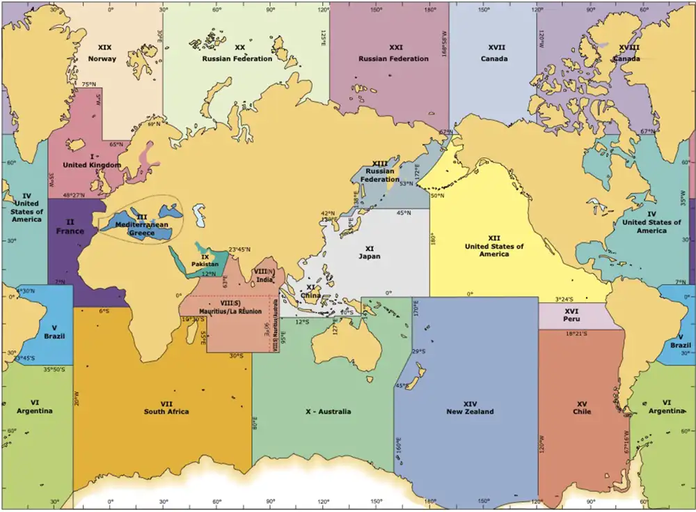
NAVAREAs: The world’s oceans are divided into NAVAREAs (Navigational Areas) as part of the World-Wide Navigational Warning Service (WWNWS). Each NAVAREA has designated NAVTEX stations responsible for issuing navigational warnings and safety information to ships transiting through that area.
Coastal Zones: In addition to NAVAREAs, coastal zones within a country’s territorial waters may have their own NAVTEX stations transmitting local navigational and safety information. These stations often broadcast on the 490 kHz frequency in the local language, complementing the international NAVTEX service provided on 518 kHz.
Structure of a NAVTEX Message
A NAVTEX message is structured to facilitate easy understanding and processing by the receiving equipment and crew. The structure typically includes:
- Header: The header contains the message’s identifier, which includes the transmitting station’s letter, the message type (designated by a single letter code indicating the nature of the message, such as navigational warning, weather forecast, etc.), and a serial number. This allows for selective reception and categorization by the receiver.
- Date-Time Group: Following the header, the message includes the date and time of the broadcast, typically in UTC, allowing the crew to assess the relevance and timeliness of the information.
- Text Body: The main content of the message provides detailed information on the navigational warning, meteorological condition, or other relevant safety information. It is written in clear, concise language to ensure that the information is easily understood by mariners.
- Ending: Messages end with an identification of the originating NAVTEX station and sometimes a repeat of the serial number for confirmation.
Limitations associated with the use of NAVTEX
While NAVTEX is an invaluable tool for maritime safety, providing timely navigational warnings, weather forecasts, and safety information, it is not without its challenges and limitations. These can affect its effectiveness and reliability, posing potential risks or inconveniences to mariners relying on NAVTEX for critical information. Here’s an analysis of some of these challenges and limitations:
Geographical Limitations: Although NAVTEX aims to provide global coverage, there are areas, particularly in remote regions or high latitudes, where NAVTEX coverage may be sparse or non-existent. Ships navigating these areas might not receive NAVTEX messages, leading to a gap in the receipt of crucial navigational and safety information.
Signal Interference: In areas with dense maritime traffic or where several NAVTEX transmitters are located close to each other, there can be signal interference, leading to the potential loss or corruption of messages. This issue can compromise the reliability of the information received.
Single Frequency Dependence: NAVTEX messages are traditionally broadcast on a single frequency (518 kHz for international messages and sometimes 490 kHz for local messages). Reliance on a single frequency makes the system vulnerable to atmospheric conditions, ionospheric disturbances, and other factors that can degrade signal quality or lead to transmission failures.
Limited Message Format: NAVTEX messages are text-based and limited in length, which can restrict the amount of information that can be conveyed in a single message. This limitation may necessitate the breaking down of complex information into multiple messages, potentially delaying the complete delivery of information.
Evolution of Alternative Technologies
With the advent of broadband satellite communications and the increasing accessibility of the Internet at sea, alternative systems such as the SafetyNET service provided via the Inmarsat satellites offer enhanced capabilities, including the transmission of graphical data and higher data rates. These technologies provide global coverage without the geographical and atmospheric limitations of NAVTEX, potentially diminishing the reliance on NAVTEX over time.
FAQs
- What is the effective range of navtex? Although it has a nominal range of 400 nautical miles, its realistic range is more like 150 .
- Is anyone allowed to use navtex or does it require a licence? For recreational or leisure vessels, such as yachts, no license is required specifically for using a NAVTEX receiver.
- Do I require a special screen for navtex or can I get the info to sent by Bluetooth to my phone? Traditional NAVTEX receivers come with their own dedicated display screens to show the received messages directly on the device. However, these days it is possible to connect NAVTEX receivers to other devices, including smartphones, tablets, and onboard computer systems.