


EPIRBs (Emergency Position-Indicating Radio Beacons) are critical safety equipment used in yachting. An emergency locator transmitter is a proper lifeline in emergencies, providing a vital link between the vessel in distress and search and rescue services. Any yacht owner needs to understand how they function, how to test them, and how to choose the suitable model, including considering a Hydrostatic Release Unit (HRU). In this latest Rubicon 3 Pro-Series article, we tell you everything you need to know about EPIRBs, from how they work, how to test them, how and where to mount them and some ideas of which emergency radio beacons are ones to look at.
How Do EPIRBs Work?
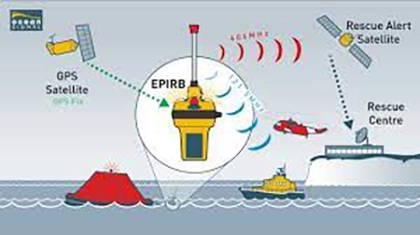
EPIRBs are designed to transmit distress signals when a vessel is in danger. In an emergency, such as a shipwreck or capsizing, an EPIRB is activated manually or automatically to send a signal to a Maritime Rescue Coordination Centre. They can be manually activated, but ideally, it has a Hydrostatic Release Unit (HRU) to allow them to float free, and they will then be automatically activated.
Transmission of the Signal & the MRCC
The signal from emergency locator transmitters is relayed via satellite to a network of rescue satellites with worldwide coverage known as Cospas-Sarsat, a global satellite-based distress alert detection system. A Maritime Rescue Coordination Centre (MRCC) plays a crucial role in responding to an Emergency Position-Indicating Radio Beacon (EPIRB) distress signal. Here’s how it works:
- Activation of EPIRB: An EPIRB is a device used on ships and boats to signal distress. When activated manually or automatically upon immersion in water, the EPIRB emits a signal.
- Signal Transmission: This signal is transmitted via satellite to a ground station. EPIRBs are typically registered with specific information about the vessel and its owner, aiding the response process.
- Alerting the MRCC: The ground station relays the distress signal and location data to the nearest rescue authority. The MRCCs are strategically located worldwide to ensure quick coordination of rescue efforts in their respective regions.
- Coordination of Rescue Efforts: Upon receiving the signal, the MRCC assesses the situation, identifies the vessel in distress, and initiates a rescue operation. This involves coordinating with various resources such as coast guard ships, helicopters, and nearby vessels that can assist in the rescue.
- Communication and Support: The MRCC communicates with the distressed vessel (if possible) and any assisting parties. They provide necessary information and support to ensure the safety of those in distress and the effectiveness of the rescue operation.
- Continued Monitoring: Throughout the rescue operation, the MRCC monitors the situation, adjusting strategies and resources as needed until the rescue is complete
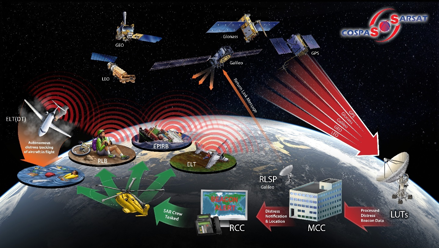
The Cospas – Sarsat Satellite System
The route of a distress signal from an EPIRB (Emergency Position-Indicating Radio Beacon) to the ultimate deployment of rescue aircraft and a Search and Rescue (SAR) team via the Cospas-Sarsat Satellite System is a complex but highly coordinated process. Here’s a summarized overview:
- Activation of EPIRB: The process begins when an EPIRB is activated, either manually by the crew of a vessel in distress or automatically upon water immersion.
- Signal Transmission to Satellite: The activated EPIRB transmits a signal at 406 MHz, picked up by the Cospas-Sarsat system of polar-orbiting and geostationary satellites. This system consists of satellites in both low-earth orbit (LEO) and geostationary orbit (GEO) and even weather satellites.
- Satellite Relays Signal to LUT: The satellite receiving the signal relays it to a Local User Terminal (LUT) on the ground. LUTs are strategically located around the world to ensure global coverage.
- LUT Processes Signal: The LUT processes the signal to determine the location of the distress. If the EPIRB is GPS-enabled, the location data is more accurate and quickly determined. Otherwise, the area is calculated using the Doppler effect.
- Transmission to MCC: After processing, the LUT forwards the distress signal and location information to a Mission Control Center (MCC). The MCC is responsible for coordinating the search and rescue response.
- MCC Alerts SAR Team: The MCC assesses the situation and alerts the appropriate Search and Rescue (SAR) authorities or team nearest to the distress location. This could involve contacting the Coast Guard, maritime rescue organizations, or other relevant agencies.
- SAR Team Responds: Finally, the SAR team mobilizes and proceeds to the distress location for rescue operations, using the location data provided by the MCC.
Transmission Frequency
An Emergency Position-Indicating Radio Beacon (EPIRB) primarily transmits on two frequencies:
- 406 MHz: This is the primary frequency used for satellite communication. Signals on this frequency are detected by the Cospas-Sarsat satellite system, which provides accurate and global coverage. The 406 MHz signal carries a unique identifier for the beacon (registered to the vessel or aircraft), enabling quick identification and aiding in coordinating rescue efforts.
- 121.5 MHz: This is a secondary homing frequency. It is used by search and rescue teams as they close in on the location of the distress signal. The 121.5 MHz frequency helps rescuers pinpoint the precise location of the beacon, especially during the final stages of a search and rescue operation.
Modern EPIRBs use the 406 MHz frequency for initial alert and location data and the 121.5 MHz frequency for local homing, providing a two-tiered approach to ensure effective and rapid response in a distress situation. The global satellite coverage of the 406 MHz frequency combined with the local precision of the 121.5 MHz frequency dramatically increases the chances of a successful search and rescue effort.
Response times to an EPIRB distress signal
The response time of rescue authorities to an EPIRB distress signal can vary depending on several factors. Generally, the sequence of events is as follows:
- Signal Transmission: When an EPIRB is activated, it begins transmitting a distress signal almost immediately.
- Satellite Relay: The 406 MHz signal is picked up by the Cospas-Sarsat satellite system. Depending on the satellite’s orbit and the beacon’s location, this can take a few minutes to, in rare cases, an hour or more.
- Ground Station Reception: The satellite relays the signal to a ground station, which usually happens very quickly once the satellite picks up the signal.
- Alerting the MRCC: The ground station processes the signal and forwards the information to the nearest Maritime Rescue Coordination Centre (MRCC). This process is fast, often occurring within minutes of the signal being detected by the satellite. Rescuers can quickly identify the boat and phone emergency contacts for more information.
- Coordination of Rescue Efforts: The rescue coordination center initiates a rescue operation. The time taken to launch a rescue mission can vary significantly, depending on the location of the distress, the availability of rescue resources (such as ships, helicopters, or other vessels), weather conditions, and the distance rescuers must travel.
The newest Cospas Sarsat satellites detect EPIRB, PLB, and ELT distress signals in almost real-time (i.e. within 5 minutes), including the beacon’s location with or without GPS. In ideal conditions, the entire process, from beacon activation to alerting rescue forces to the MRCC, can take as little as 15-20 minutes. However, the time from activation to rescue arrival can be several hours, especially if the distressed vessel or individual is in a remote or difficult-to-access area.
What Are The Advantages of a GPS EPIRB?
An EPIRB that sends a GPS position is typically called a “G-PIRB” or “406 MHz GPS EPIRB.” This type of EPIRB incorporates an internal GPS, providing significant advantages in a distress situation:
- Enhanced Positional Accuracy: The primary advantage of a GPS-enabled EPIRB is the increased accuracy of the position data it transmits. Traditional EPIRBs rely on the Doppler effect for location determination, which can have a positional accuracy of about two nautical miles. In contrast, GPS-enabled EPIRBs can provide location data with an accuracy of around 10 meters or better.
- Faster Location Fix: GPS-enabled EPIRBs can obtain and transmit an accurate position fix faster than non-GPS EPIRBs. This rapid location determination is crucial in an emergency, allowing for a quicker response from search and rescue services.
- Reduced Search Area: The precise location data from a GPS-enabled EPIRB significantly reduces the search area, enabling rescue teams to focus efforts and commence rescue operations more efficiently.
- Improved Response Times: With accurate GPS coordinates available immediately, search and rescue operations can be initiated with a clear destination. This precision can significantly cut down the time rescue teams take to reach the distressed vessel, which is particularly vital in severe weather conditions or remote locations.
- Better Coordination of Rescue Efforts: The precise location information aids in better coordination among rescue assets such as ships, aircraft, and helicopters. It allows rescue coordinators to make informed decisions about which resources to deploy and the most effective approach to the rescue.
- Reliability in Dynamic Situations: In situations where a vessel may be drifting or in rough sea conditions, the continuous update of position via GPS ensures that the most current location is always known, which is vital for a moving or sinking vessel.

What Are The Advantages of an AIS EPIRB?
An AIS (Automatic Identification System) EPIRB, which combines the features of a traditional EPIRB with AIS technology, offers several advantages in a maritime distress situation:
- Enhanced Local Positioning and Tracking: AIS EPIRBs transmit the distress signal and location information to satellites and directly to nearby vessels equipped with AIS receivers. This local broadcasting can significantly expedite rescue efforts, especially in heavily trafficked waters where other ships can provide immediate assistance.
- Real-Time Location Updates: Unlike traditional EPIRBs or GPIRBS, which tell you a search area or a latitude and longitude, the AIS signal can be directly integrated into the ship’s electronic systems, like chart plotters and marine radars. This integration allows immediate visualization and better situational awareness for the crew on the distressed vessel and nearby ships. As such, an AIS EPIRB shows you directly on the screen where it is and how far you are from it, which can be crucial in dynamic sea conditions.
- Increased Visibility to Nearby Vessels: AIS signals are received by all nearby AIS-equipped vessels and shore-based receivers. This increases the visibility of the distress situation and can lead to a quicker response from nearby ships, even before formal search and rescue teams are deployed.
- Dual-Frequency Advantage: AIS EPIRBs use the global 406 MHz frequency for satellite communication and the local AIS frequencies (161.975 MHz and 162.025 MHz). This dual-frequency approach ensures wide-area alerting and local precision in pinpointing the location.
- Identification Information: AIS EPIRBs will transmit identification information, such as the vessel’s name or call sign. This can be crucial during search and rescue operations, especially in busy maritime areas where multiple vessels may be present.
What Is a Return Link Service or RLS?
Return Link Service (RLS) is a relatively recent enhancement in the functionality of EPIRBs. It provides a feedback mechanism to the user, confirming (through a visual or audible signal) that their distress signal has been received and processed. This would be a blessing for someone in distress who otherwise would have to hope that the satellite processing the signal had been picked up. The role of hope in a survival situation is enormous, so this functionality should be considered.
What is the difference between an EPIRB and a PLB?
EPIRBs and PLBs (Personal Locator Beacons) are emergency distress signalling devices that alert search and rescue services. They are, however, designed for different contexts and have some distinct differences:
EPIRB
- Intended Use: Primarily to signal that a vessel is in distress. EPIRBs are designed to be mounted onto the boat.
- Size and Portability: Generally larger and less portable than PLBs. They are meant to stay with the vessel.
- Battery Life: EPIRBs usually have a longer battery life in operation, often around 48 hours once activated, which is suitable for maritime emergencies involving longer rescue times.
- Registration: They are registered to a vessel with information about the boat and its owner, aiding in the rescue process.
- Signal Strength and Durability: Designed for the harsh marine environment, they are robust and have strong signal strength.
PLB (Personal Locator Beacon)
- Intended Use: Designed for personal use, these are most commonly installed into the life jacket and can then be activated manually or by the inflation of the life jacket.
- Size and Portability: PLBs are smaller, more compact, and portable, designed to be carried by a person.
- Battery Life: Typically, PLBs have a shorter operational battery life than EPIRBs, around 24 hours, which is generally sufficient for individual rescue.
- Registration: Registered to an individual rather than a vessel. The registration includes personal information that can assist rescuers.
- Signal Strength and Durability: While durable and reliable, PLBs are designed for individual emergencies and may not have the same range or signal strength as EPIRBs. Newer PLBS also have an AIS signal, which is highly recommended to aid rescue by nearby vessels.
How Do You Register Your EPIRB?
Ensuring you, as the beacon owner, have a properly registered EPIRB (Emergency Position-Indicating Radio Beacon) is crucial in ensuring the device’s effectiveness in an emergency situation. Registering your EPIRB is not just important; it’s often legally required. Registration ensures that search and rescue teams have the necessary emergency contact information to respond effectively in the event of an emergency. You must provide information about the vessel, contact information, and the EPIRB’s unique identification number (UIN). The registration process varies slightly depending on the country. Below are the general guidelines for registering an EPIRB in the USA, Canada, the UK, and Europe:
In the United States, EPIRB registration is managed by the National Oceanic and Atmospheric Administration (NOAA). Registration can be completed online through the NOAA website. In Canada, EPIRB registration is handled by the Canadian Beacon Registry, which is part of the Canadian Coast Guard. The Maritime and Coastguard Agency (MCA) oversees EPIRB registration in the UK. In Europe, the registration process varies by country. Each country has its own authority responsible for beacon registration. Whichever authority your EPIRB is registered under, you must ensure the information is kept accurate and up to date. These are not to be used lightly, and you may receive warning letters or be fined by the Federal Communications Commission (FCC) for false activation of an unregistered EPIRB. Remember, your life may be saved due to the registered emergency information.
Testing your EPIRB
- Read the Manufacturer’s Instructions: It’s essential to consult the EPIRB’s manual before testing. Different models will have specific testing procedures and recommendations.
- Use the Test Function: Most EPIRBs have a built-in self-test function that simulates an activation without sending a distress signal. This usually involves pressing a specific test button.
- Visual and Audible Indicators: Observe the visual (LEDs) and audible indicators during the test. The EPIRB should confirm that the internal electronics, battery, and GPS (if equipped) are working correctly.
- Do Not Activate the Beacon: Never test an EPIRB by activating it as if in a real emergency. Doing so sends a false alarm to search and rescue services, which is illegal and can lead to fines.
- Check Physical Condition: Inspect the beacon for any physical damage, corrosion, or water ingress.
- Battery Status: Check the battery indicator, if available, to ensure the battery is in good condition. Most batteries will have an expiry date, and it can take a while to get a new one, so check
When to Test an EPIRB
- Regular Testing: Manufacturers typically recommend testing your EPIRB once a month.
- Before a Voyage: Always test the EPIRB before heading out on a trip, especially if it’s a long or challenging journey.
- After Prolonged Storage: If the EPIRB has been stored for a long time, test it before using it again.
- After Servicing or Battery Replacement: Test the EPIRB after any service or battery replacement to ensure it’s functioning correctly.
Important Notes
- Adhere to Testing Limits: Some EPIRBs have a limit on the number of tests that can be performed to prevent excessive wear on the battery. Always follow the manufacturer’s guidance.
- Avoid False Alarms: Ensure your testing does not accidentally send a false distress signal.
- Professional Inspection: In addition to regular self-testing, it’s advisable to have the EPIRB professionally inspected and serviced according to the manufacturer’s schedule, typically every few years.
Testing your EPIRB regularly and correctly is crucial for your safety at sea, so don’t skip it!
How To Use An EPIRB Beacon In Case of Emergency
You’ll need to activate your EPIRB if your vessel is in immediate danger or if there is a medical emergency onboard for which you cannot radio for help.
- Ensure Safety First: Before activating the EPIRB, ensure that you and your crew are in a safe location, if possible. This might mean boarding a life raft if you are on a vessel.
- Manual Activation:
- Remove from Bracket: Take the EPIRB from its mounting bracket or storage location.
- Extend the Antenna: Fully extend the EPIRB’s antenna.
- Turn On: Activate the EPIRB by following the specific instructions for your model. This usually involves moving a switch to the ‘ON’ position or pressing and holding a button.
- Keep the Antenna Upright: Ensure that the antenna is vertical and unobstructed to allow the signal to transmit effectively.
- Automatic Activation: If you have an automatically activated EPIRB (common in maritime environments), it will activate upon immersion in water via the Hydrostatic Release Unit (HRU). However, it’s still advisable to manually ensure it’s activated.
- Position the EPIRB:
- On Land or a Life Raft: Place the EPIRB outside, where it has a clear view of the sky.
- On a Vessel: Attach it to the highest possible point to avoid obstruction.
- Do Not Move the EPIRB: Keep the EPIRB still and upright once activated. Moving it around can make it harder for satellites to pinpoint your location. Most emergency locator transmitters will also have strobe lights to aid visual location.
- Wait for Rescue: Keep the EPIRB transmitting. Rescue may take time, especially in remote areas.
- If Rescued: Once safe, turn off the EPIRB to avoid sending a continued distress signal.
What to do if you accidentally activate the EPIRB
If a distress signal is transmitted accidentally, you should stop the transmission immediately, and the local rescue coordination centre should be contacted and informed. Somebody should also notify the nearest Cospas-Sarsat mission control centre (MCC)
Which is the best EPIRB to buy?
There is no one best or correct EPIRB to buy. When selecting one, you need to consider factors like size, battery life, GPS integration, and specific features you want, such as AIS and RLS, all of which affect the price.
Our choice
- ACR GlobalFix Pro v5: This EPIRB is a superb piece of emergency equipment with long battery life, GPS data, AIS signal and RLS functionality.
Other options worth exploring:
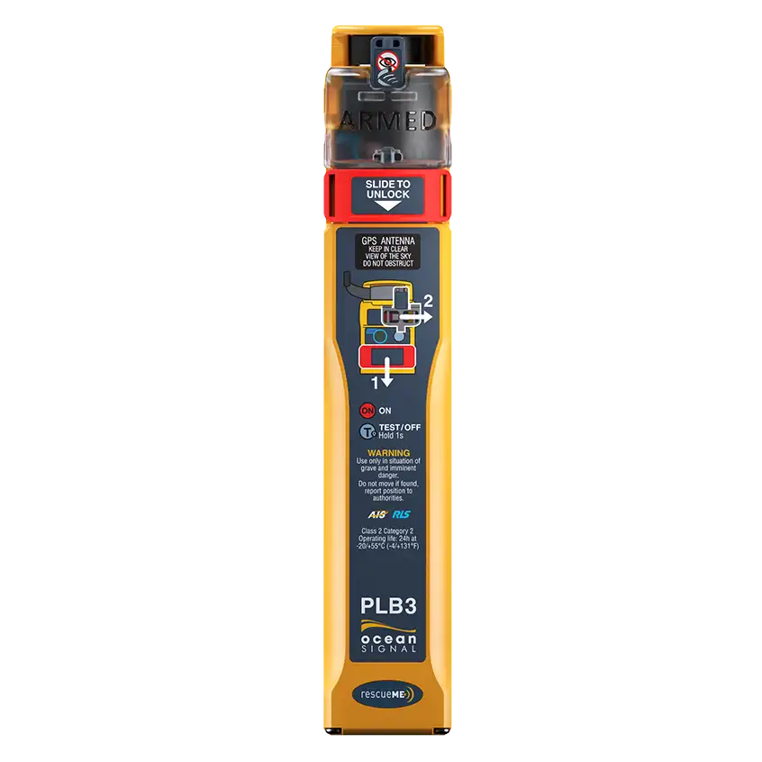
- Ocean Signal EPIRB3 RescueMe: Known for its compact size and reliability, it is about 30% smaller than average EPIRBs and includes a retractable antenna. It has a battery life of 10 years and a 48-hour operational period once activated. This EPIRB also has AIS and RLS.
- Ocean Signal SafeSea EPIRB1 Pro: Known for its compact design and 10-year battery life, the EPIRB1 Pro operates on the 406 MHz satellite band and comes with an automatic release housing for hands-free deployment. It’s a bit heavier than some competitors but is highly effective and suitable for water-based activities.
- ACR GlobalFix V4: The GlobalFix V4 offers a user-replaceable battery, 48+ hours of operational life, and a simple stowage bracket. It’s a larger unit requiring more space, but it’s highly reliable, featuring an internal 66-channel GPS and a high-visibility LED strobe light. The bracket holds the antenna and deploys instantly upon release.
- McMurdo SmartFind G8 AIS EPIRB: This EPIRB includes an AIS transmitter that provides location information to nearby vessels and a 77-channel multi-constellation GNSS receiver. It offers manual/automatic activation, a strobe light, and a 48-hour operational time with a 10-year battery life before replacement is needed.
- GME MT600G GPS EPIRB: This device has a 48-hour operational battery life and includes a mounting bracket. It’s equipped with a GPS but lacks AIS and NFC features. This EPIRB is a good option for those who need a reliable, basic unit.